
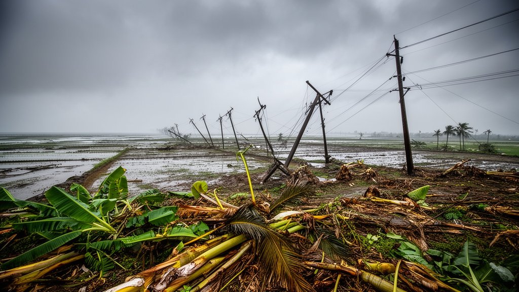
Severe Cyclonic Storm Gaja, which made landfall on the southern coast of India in November 2018, remains a definitive case study in disaster management, meteorological prediction, and the long-term economic vulnerability of agrarian coastal regions. The storm, which struck the Tamil Nadu coast between Nagapattinam and Vedaranyam, brought sustained wind speeds of 100–110 kmph, gusting up to 120 kmph, resulting in significant loss of life and catastrophic damage to local infrastructure. This retrospective analysis explores the systemic impact of the storm and the lessons learned by the Indian Meteorological Department (IMD) and the Tamil Nadu State Disaster Management Authority (TNSDMA) during one of the most challenging climate events of the decade.
Key Highlights
- Date of Landfall: November 16, 2018, with the eye of the storm crossing the coast between Nagapattinam and Vedaranyam.
- Wind Intensity: Sustained speeds of 100-110 kmph with gusts reaching 120-130 kmph.
- Displacement: Over 82,000 people were successfully evacuated to over 400 relief centers before landfall.
- Casualty Figures: The storm resulted in more than 45 fatalities across affected districts.
- Agricultural Impact: Massive destruction of the Cauvery Delta’s coconut and banana plantations, causing long-term economic distress.
The Meteorological Mechanics of Gaja’s Path
The Anatomy of a Severe Cyclonic Storm
The formation of Gaja highlighted the volatile nature of the Bay of Bengal during the post-monsoon period. Initially detected as a low-pressure area, the system intensified rapidly as it traversed the warm waters of the Bay. The IMD classified Gaja as a ‘Severe Cyclonic Storm,’ a designation that triggered high-alert protocols across coastal Tamil Nadu and Puducherry. The storm’s cyclonic path was characterized by erratic movement, necessitating complex tracking models that challenged local authorities to pinpoint the exact window of landfall.
The Landfall: A Coastal Crisis
When the eye of the storm crossed the coast between Nagapattinam and Vedaranyam in the early hours of November 16, it brought a lethal combination of high-velocity winds and storm surges. The wind speeds, estimated at 110 kmph, decimated fragile structures. Unlike typical monsoonal rainfall events, Gaja was defined by its wind power, which proved far more destructive to the region’s man-made and natural landscape than the water itself. The sudden shift in wind direction as the eye crossed the coast created a ‘whiplash’ effect, causing additional structural failure in houses that had initially withstood the primary impact.
The Humanitarian and Infrastructure Crisis
Evacuation and Sheltering Operations
The TNSDMA executed one of the largest evacuation operations in recent state history. By mobilizing district administrations, authorities moved over 82,000 residents from vulnerable coastal villages into temporary shelters. The efficiency of this mobilization is widely credited with keeping the death toll significantly lower than it might have been, given the intensity of the storm. Emergency services, including the National Disaster Response Force (NDRF), were pre-positioned strategically to minimize the time between the storm’s impact and the start of rescue operations.
Power and Communication Infrastructure Collapse
The storm dealt a catastrophic blow to Tamil Nadu’s energy grid. Over 100,000 electricity poles were snapped or uprooted, plunging entire districts into darkness for weeks. The sheer scale of the pole-and-transformer failure underscored a critical vulnerability in the regional grid: the lack of underground cabling and reinforced infrastructure in hurricane-prone zones. Communication networks, dependent on these power grids, also collapsed, creating a temporary information blackout that hindered early assessment of the inland damage.
Economic Devastation and Agricultural Toll
The Cauvery Delta’s Heavy Burden
The Cauvery Delta, known as the ‘Rice Bowl of Tamil Nadu,’ bore the brunt of the storm’s economic impact. The high-velocity winds did not discriminate; millions of coconut, banana, and jackfruit trees were uprooted or snapped. For the small-holder farmers of the region, this was not just a loss of a single season’s crop, but a total loss of agricultural capital that would take years to replant and recover. Reports indicated that over 80,000 hectares of farmland were severely affected. The economic ripple effect extended to the coconut oil and coir industries, which faced a raw material crisis that lasted for several years following the event.
Long-term Reconstruction Challenges
Post-Gaja, the recovery efforts focused on balancing immediate humanitarian aid with long-term agricultural rehabilitation. State compensation packages were rolled out to assist farmers in clearing debris and purchasing saplings. However, the event highlighted the necessity of climate-resilient farming and the urgent need for a more robust disaster-resistant power infrastructure. The transition from restoration to resilience has become a core component of state planning in the years since the storm.
FAQ: People Also Ask
1. Why was Cyclone Gaja so destructive to the Cauvery Delta?
The primary reason was the storm’s high-velocity winds, which were specifically damaging to the tall tree plantations—coconut and banana—that dominate the Cauvery Delta’s agricultural landscape. The region’s geography also made it a direct corridor for the storm’s entry, maximizing the wind’s destructive force.
2. How did the evacuation process influence the survival rate during Cyclone Gaja?
The proactive evacuation of over 80,000 people to pre-designated, durable cyclone shelters was the primary factor in minimizing human casualties. Pre-positioning of the NDRF and local emergency teams allowed for immediate search and rescue, effectively managing the crisis despite the loss of communication infrastructure.
3. Are there long-term climate implications for the Bay of Bengal seen in events like Gaja?
Yes. Meteorologists and climatologists observe that the Bay of Bengal is experiencing more frequent and intense cyclonic systems due to rising sea surface temperatures. Gaja is frequently cited in academic studies as an example of how ‘severe’ intensity storms are challenging existing disaster preparedness thresholds.
4. What was the impact on the electricity grid?
The storm caused a massive, systemic failure, with over 100,000 electricity poles destroyed. This highlighted the need for infrastructure hardening, such as the implementation of underground power lines in coastal districts to withstand future high-wind events.